Real-time stratospheric balloon flight data
We help hundreds of students discover the limits of the Cosmos
During 2021, we were approached by the educational project Touch the Cosmos, who were looking for a partner – a map specialist who would be able to provide a software solution for the visualization of the movement of stratospheric balloons in real time.
45 teams of schoolchildren and students were created. Each team launched their own stratospheric balloon to the edge of the Cosmos and took unique photographs of the Earth’s curvature from a height of 30 kilometers. During the flight, they were able to monitor the current position of the balloon, as well as other data, such as the current temperature and air humidity.
ABOUT THIS CLIENT
Touch the Cosmos inspires students and helps schools and the general public introduce STEAM (Science, Technology, Engineering, Arts, Math) education methods and make science projects, activities, experiments, and exploration a natural part of the education system.

0
Teams
0
+
Sent flight GPS
0
+
Involved schools
Real-time flight data transmission
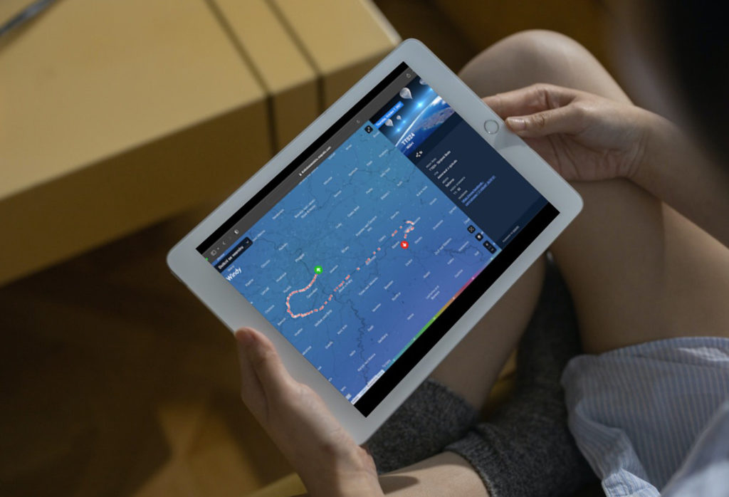
The biggest challenge was conveying the real-time position of the vessel and other sensory data in a matter of seconds. This was key to the “catcher” being able to locate the balloons upon landing. The current position of the flying balloon was shown on the map by the icon of the balloon, which left behind a line indicating the route flown. In the sidebar, information such as the current measured temperature, humidity, etc. was available.
Touch the Cosmos map on their own domain
For achieving the maximum potential of our map solution, we chose a map layer with a graphic visualization of the current air flow by Windy.com. Thanks to this, the students were able to see the changes in the direction and speed of their balloon depending on the air flow.
The challenges we faced while working on the Touch the Cosmos project:
Real-time connection to the service providing flight data
Integration of map layers with weather
Rendering of active vs. inactive balloons
Specific content structure for school teams
Back office for metadata settings and imports
Easy-to-use mobile version for people in the field
Map on their own domain, as well as embedded on the client's website
A map with live data was available on a specially created domain. The client could provide it for flight tracking both to the school teams themselves, as well as to journalists. But at the same time, they could easily embed the map on their website or blog.
What’s more is that the map remains available even after the end of the project – all flights that have taken place can be viewed on the map. Have a look yourself at dotknisevesmiru.mapotic.com.
"We chose Mapotic for our balloon data visualization solution because they were one of the few able to create a map that was precisely customized to the needs of our teams, but also helped us when communicating with the media. The Mapotic team did a great job and we look forward to continuing our cooperation in the future."
Rostislav Konopa, a Founder of the Touch the Cosmos project
Visualization of dynamic data
We enjoyed working on the Touch the Cosmos project thanks to its challenges and the opportunity to participate in an educational project for primary school students. In a world that is filled with various motion and sensory data from almost any electronic device, displaying data visualization in various contexts has enormous potential. We do hope that we managed, together with the authors, to get more than one student excited about the given issue.
If you’re interested in the other potential uses for dynamic and motion data visualization, check out our other case studies.

Platform uses
Mapotic can be used in various use cases
Static or dynamic data
Processing and aggregation of various location dynamic data
Web or mobile apps
Web versions and branded mobile applications
Public or private
Public portals and customer application or internal systems
Standalone or embedded
Processing and aggregation of various location dynamic data
Full or headless
Turn-key solutions or backend and data processing only
Business or non-profit
Location data and tracking in business or helping the planet