Argos Systems is one the best global telemetry solutions used for environmental monitoring and specifically, wildlife tracking. Having multiple tracking systems on board, connection to the Argos platform is one of the most important environmental data sources for our Sustainability and Wildlife tracking map visualizations.
WLC has been one of most important organizations providing advanced wildlife telemetry solutions since the 1980s. They initially specialized in marine tags, but over the decades have grown into an important provider of tracking and telemetry devices to thousands of projects, as well as the entire scientific community.
Movebank is an online platform that was created to help scientists and researchers manage, share, and analyze animal movement data. Mapotic has built a connector that connects to Movebank and allows you to build amazing, visually attractive apps based on Movebank tracking data.
After placing your tags on animals or track objects, you can simply connect it to Mapotic and start adding more value for your target audience. Mapotic enables you to post-process tracking data (i.e. filter out only the highest quality GPS or randomizing data for reducing poaching risks) and enrich tracking data with meta information (images, descriptions, custom fields).
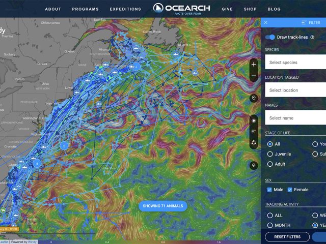
You can extend your tracking data with further parameters and automatically group tracked objects. Imagine tracking turtles and having multiple attributes that enable users to easily filter by subspecies or stage of life.
Mapotic enables you to customize outputs and build attractive map visualizations using state of the art map layer providers such as Windy, OpenWeather maps, ESRI, and more. You can visualize your data within weather animations, enable users to filter with custom filters you’ve built, and more.
Thanks to our pre-built apps, you’ll be able to easily embed map visualizations into pre-existing websites or mobile apps. In addition, you can have one built and branded for your organization.