Čertovo jezero
Mapa české republiky
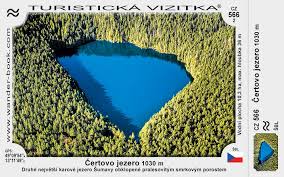
Description: Leží na jižním svahu Jezerní hory. Maximální hloubka je 36,7 metrů. Vzniklo díky postupném tání ledovců.
Comments
Mapa české republiky was created by Free Custom Map Builder that powers thousands of custom online maps.
Want to build own custom map for your business or community? Try Mapotic's custom map maker and create customizable or branded maps in minutes. Leverage filters, custom categories, crowdsourcing and SEO. Create a free custom map.