MOTION TRACKING
With the Slovak Tatra National Park, we built a system for monitoring the movement of tourists
The TANAP team has long struggled with inaccurate data on the number of people visiting the Tatras. Insufficient statistics made it difficult to plan new investments and for administrators to manage tourism. So this time, we used our mapping technology to create an online service that tracks visitor movements in the Tatras and gives conservationists, foresters, and rangers an accurate overview of the state of tourism.
ABOUT THE CLIENT
Tatra National Park (TANAP) is the oldest national park in Slovakia. It is visited by around 3.5 million tourists and other mountain lovers annually. There are around 600 kilometres of official hiking trails. Tatra nature lives its own life, but it is increasingly influenced by humans. Therefore, it is important to be aware of and correct the amount of movement in the Tatras.
Real-time people counting in nature.
Objective of the project: Creating a new platform for monitoring tourism in the whole area of the Tatras
In 2021, TANAP approached us with a plan to improve the tourism monitoring system in the park. They knew that we at Mapotic had experience with tracking maps and could give them accurate numbers not only about the movement of people, but also about temperatures in certain areas of the park.
The TANAP team already had the numbers of visitors to the park before our cooperation, but it was not enough. They get data from several sources – for example, from accommodation operators or carriers. However, day tourists or those staying in private accommodation often slip through the cracks. They also have information from an annual census of tourists in the mountains, but the data is not accurate and the results do not help to determine anything about trends in visitation. Improvements can be made by working with mobile operators who will provide TANAP with their data. However, this will cost the park managers a lot of money and they will only get data for the whole area, which will not be broken down into individual areas as the people of the park would need.
Challenges we dealt with in the national park project
Monitoring movement in difficult terrain
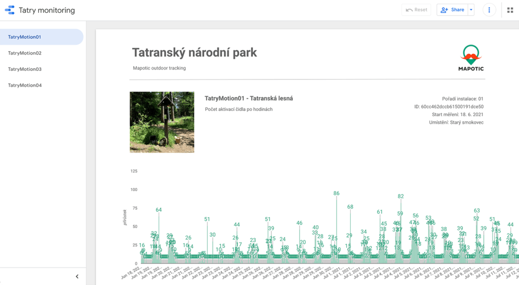
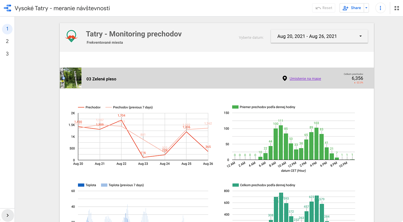
Data on the movement of people, temperatures in the area, and more
Measuring with low-power sensors
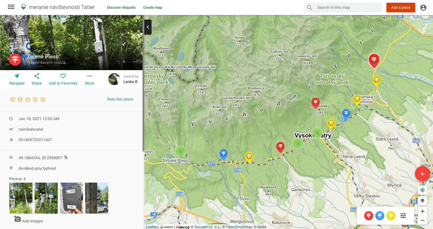
Maps, analytical dashboards, or heat maps as a result
Detailed statistics and options for further work with the data
Tested with a pilot project
Implementation: Online monitoring with low-power sensors
We set about selecting the most suitable monitoring equipment and fine-tuned the system for transmitting sensor data. We used the technology of monitoring moving objects (visitors to the Tatra Mountains), as well as a large number of data obtained from predetermined locations. For example, temperature measurements in precisely defined locations in the park. We transmit data from remote locations to the system using telemetry.
We have long been looking for ways to gather information on visitor numbers. The available statistics do not manage to capture the necessary information. In cooperation with mapotic, we have installed meters directly in the field, which continuously send us data on the movement of tourists, which mapotic has clearly visualized for us. This gives us slightly better information on tourist behaviour, which we can share with other institutions in the region and thus work together to better manage visitors."
Ing. Lenka Rusnáková, Executive Director
Result: A flexible tool for keeping track of what's happening in the national park
By launching the monitoring of tourists in the Tatras, the administrators will finally get accurate data on visitor numbers. They will know which routes are overloaded and in urgent need of increased capacity. They will also be able to see where it does not make sense to plan investments at the moment.
The sensors can be moved around the park to measure data in different places. Thanks to this, the TANAP people, in cooperation with the Mapotic team, can gradually fine-tune their most suitable location.